Super Interactive Maps for WordPress 2.3
Wordpress Plugins Codecanyon 4.8 (244 reviews)
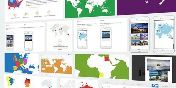
Super Interactive Maps for WordPress adds detailed, clickable vector maps to your site without requiring any external services or complicated code. The plugin works right from your WordPress dashboard, letting you insert maps into posts, pages, or widget areas. Inside the single plugin package you’ll find over 300 ready-made maps, covering all 195 recognized countries, every continent, and many specific regions and territories. These maps are built as SVG and vector graphics, so they remain sharp on high-resolution screens, and they scale naturally to fit whatever space you give them. Since the maps are fully interactive, visitors can hover over areas to see names, click regions to trigger actions, and pan or zoom where the map allows. The entire set is included with the plugin, meaning you don’t need to download individual map files or pay extra per region. It’s a straightforward way to bring geography into a WordPress project, whether for a travel blog, a business locator, or an educational resource.
Related products

 Codecanyon


Setting up a map on your WordPress site starts with creating a new map instance and choosing which of the included regions you want to display. The configuration screen presents options for styling individual countries, changing colors, adding tooltips, and linking each region to a URL or custom action. You can decide how much interaction the visitor should have, such as enabling zoom controls or making a map purely informational. Because the maps are drawn using vectors rather than loaded image files, they load quickly and look consistent across different browsers and devices. The plugin uses a similar set of map data for both the world map and individual country maps, so if you need to show a global overview and then let visitors click through to country-specific views, the style and behavior stay consistent. The interface is designed for users who may not have coding experience, but the underlying map objects are accessible for developers who want to customize further.
The included map collection covers substantial ground. You get a complete world map with all countries individually selectable, plus separate maps for each continent, such as North America, South America, Europe, Asia, Africa, and Oceania. In addition, there are regional maps that break down areas like Western Europe, Southeast Asia, the Middle East, and the British Isles. For individual countries, the plugin includes maps with internal administrative divisions or states, depending on the country. This makes it possible to show data at a more local level, like displaying sales regions within the United States or provinces within Canada. Every map uses the same basic structure, so learning to configure one map teaches you how to configure them all. The maps are also responsive, which means they automatically adjust to fit mobile screens, tablets, and desktop monitors without any extra code or separate mobile versions.
For anyone who needs geographic visuals on a WordPress site, this plugin removes most of the work. The map files are already prepared, the interaction options are consistent across all regions, and the SVG format means you don’t have to worry about pixelation or file size blowing up your pages. You can use the maps to show location-based content, illustrate travel routes, present demographic information, or simply give your visitors a better sense of place. Since everything ships inside the plugin, there’s no dependency on third-party map providers or API keys. That also means the maps keep working even if an external service changes its terms. The plugin is distributed as a standard WordPress plugin file that installs like any other, and it appears in your plugin list just the same. Whether you’re building a small niche site or a larger project with multiple maps, the included collection gives you a solid start.
- Last updated
- August 12, 2026
- Delivery
- Digital
- Availability
- In stock
- Version
- 2.7
- Category
- Wordpress Plugins
- Item type
- plugin
Super Interactive Maps for WordPress is one of the Wordpress Plugins items recorded as a plugin. The content below uses the supplied listing information and current local catalog data.
Usage rights depend on the license selected at checkout. Review the complete terms before using this item for client work, redistribution, SaaS, or more than one end product.